Precision farming systems relying on getting clear satellite images at the right time have so far struggled to deliver on their high potential value. Not anymore because UK technology companies Origin Digital and Aspia Space have developed a technique that is able to see through clouds.
Called Clearsky, and described as a game-changing service that could change the way satellite imagery is used, the technology uses radar to penetrate clouds. Data is fed into a deep neural network which creates a view of a field that a satellite would see if there were no clouds blocking its camera.
Farmers using the service are guaranteed to receive an image every six days showing them how their crop is developing, whatever the weather. This is in contrast to traditional, weather-dependent imagery which can often have gaps of several weeks between cloud-free views.
“This is a hugely exciting development, because it adds the ingredient of dependable regularity that’s missing in traditional imagery services,” said Madhumita Mund Rao at Origin Digital, who reckons this reliability will give UK farmers a new advantage to optimise inputs.
Analysis by Origin Digital shows that Sentinel 2 satellites produced an average of 13 clear images per UK farm in 2021. In contrast, the Clearsky technology produces more than 60 cloud-free images a year, which can be used alongside the clear images captured by Sentinel 2 and other providers.
“Even in the presence of 100% cloud cover, we can deliver regular, reliable, and consistent cloud-free images that are easily understood and can be analysed in exactly the same way as regular optical imagery,” added Aspia Space co-founder professor Jim Geach.
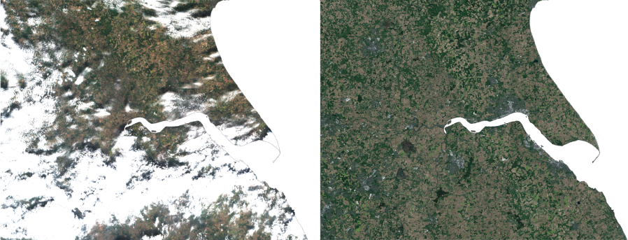
Picture: A direct Sentinal-2 RGB view of the Humber region (left) and the equivalent Clearsky prediction for the same day (right).