CultiWise allows you to create application maps for spot spraying from photos taken by a drone. We went to see the mapping process in action using both small and larger UAVs.
KEEPING IT BRIEF
- CultiWise is a cloud-based software that processes satellite images and drone photos.
- The AI detects green plants in high-resolution images and even distinguishes between species.
- The application maps can be exported to various terminal brands.
Digital tools have become an important aid for farm managers, with developing technology allowing the use of geospatial data to provide detailed information about their fields, often sourced from satellite remote sensing images.
However, the sky is not always cloudless. And this is exactly when camera drones come into their own for mapping fields — especially when the task is to find patches of weeds or even identify weed species. The requirements are a camera that should offer the highest possible resolution and software that stitches the drone photos together into so-called orthophotos (corrected images which combine the characteristics of a photograph with the geometric accuracy of a map) and then analyses these.
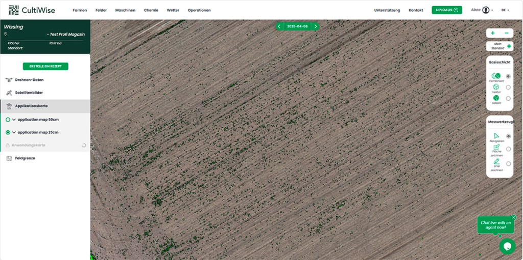
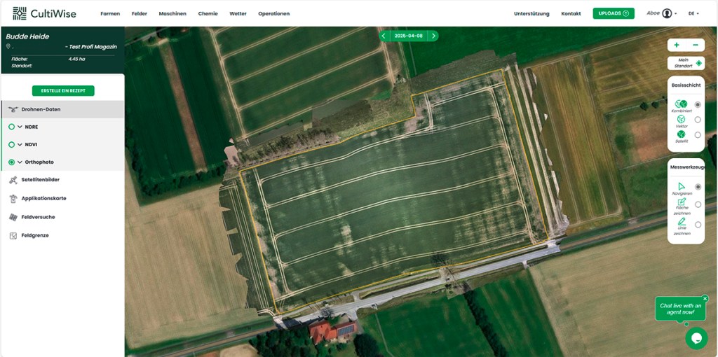
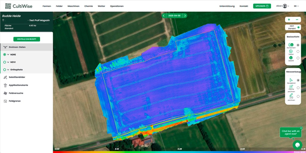
CultiWise is one such software. It displays Sentinel-2 satellite generated images and drone-created photos of agricultural land. These images can be used by farmers to generate application maps.
The CultiWise portal
SkyMaps, based in Brno, Czech Republic developed the cloud-based software and markets it across Europe via cultiwise.com. Agricultural machinery dealer Titan Machinery has been handling sales and support in Germany through its precision farming division.
There are several subscription versions:
- Pro costs €14 (£12.18) per hectare per year and produces application maps for variable-rate application of fertiliser, seeds and chemicals.
- Pro+ costs €20 (£17.40) per hectare per year and enables selective herbicide applications, plant counts, crop damage analysis, weed detection and spot spraying.
SkyMaps provides 1 TB of storage free of charge on its server for saving drone photos. If more storage is needed, it is charged at €300 (£261) per TB per year. In Titan Machinery’s experience, 1 TB should usually be enough for covering 600ha of land per season.
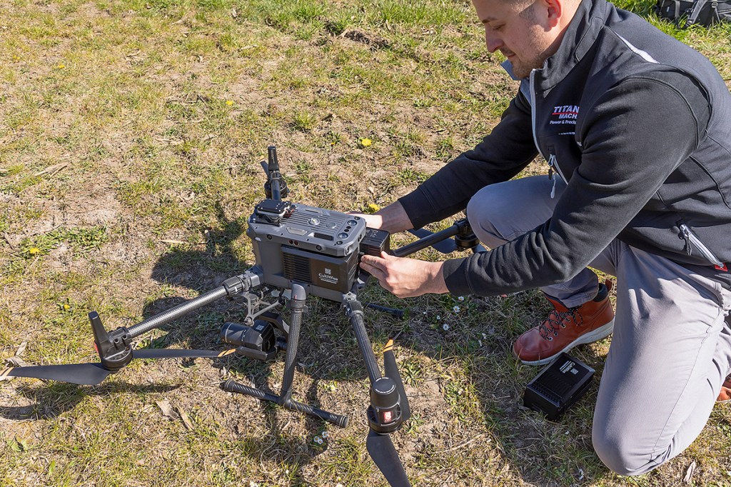
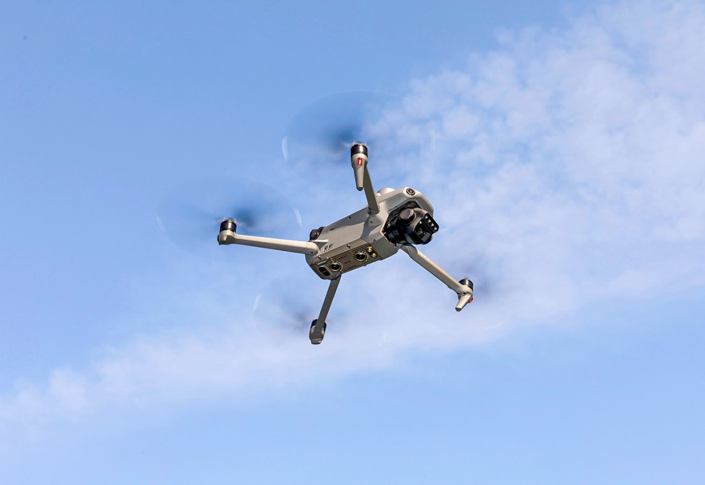
The Mini and Scout drones
For flying over and mapping fields, SkyMaps offers two off-the-shelf DJI drones of different sizes. The smaller DJI Mavic 3M weighs 950g. At SkyMaps, it is called the CultiWise Mini. It is fitted with an RGB camera with 20-megapixel (MP) resolution and a 5 MP multispectral camera.
The image resolution performance is sufficient for detecting and identifying weeds while flying at a suitably low height. However, the work rate is only 16ha/hr. The CultiWise Mini package with three extra batteries and a charging station costs €4,200 (£3,654). That also makes it suitable for use by individuals who have the small drone licence (Flyer ID and Operator ID in the UK).
By comparison, the larger DJI Matrice 350 RTK is geared at service providers who want to offer field mapping as a service with the CultiWise Scout version marketed by SkyMaps and Titan Machinery priced at €34,640 (£30,136). Included in the price are the DJI drone, a 25 MP MicaSense multispectral camera, a 45 MP Zenmuse RGB camera, brackets and two extra gimbals, plus four spare batteries.
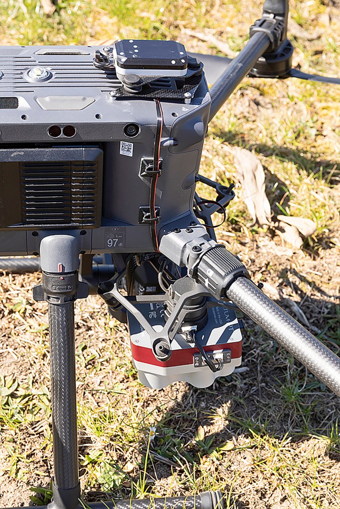
The five light-wave sensors in the multispectral camera on the CultiWise Scout distinguish five colour channels. A sun sensor measures solar radiation to ensure high measurement accuracy even in changing light. Thanks to the high-resolution cameras, the AI-based image analysis in CultiWise can even detect and distinguish weeds in green crop stands (green-on-green).
Planning the flight mission
Both DJI drones are fitted with an RTK module, so the exact location of the images can be determined with centimetre accuracy. One important point is that when spot spraying subsequently using a map generated from the drone photos, the same RTK correction that was used for mapping should be used for spot spraying as well. If not, offsets and inaccuracies can occur.
For planning a flight mission, you should have imported the field boundaries into CultiWise. From CultiWise, you can export the data in the right format to a USB stick and load it into the drone’s control terminal. The pilot then plans the flight mission on the colour touchscreen – a quick and straightforward process.
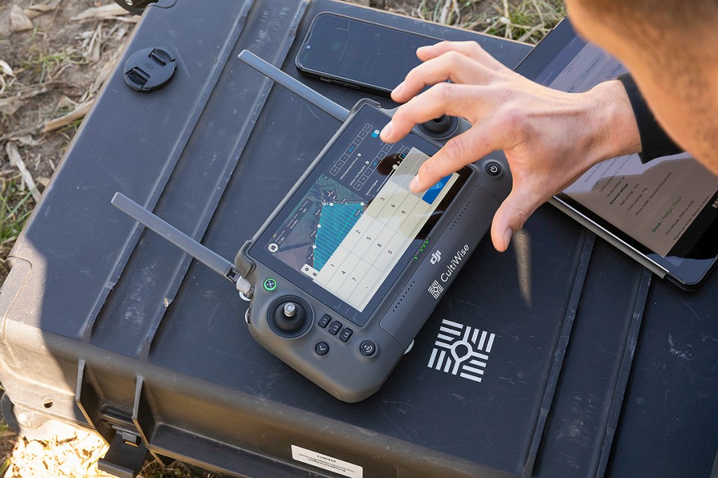
In the settings menu, you set the flight height (e.g. 40m) and velocity (e.g. 5m/s). These settings together with the overlap set per image determine the number of images produced per hectare, as the photo shooting intervals are controlled by distance covered.
For mapping a field for subsequent spot spraying, Titan Machinery recommends a flight height of 40 to 60m — depending on how easy it is to identify weeds in the crop stand. If the drone images are only meant to show biomass, flight heights of up to 100m are possible.
As a rule, fly as high as possible and as low as necessary. At a lower altitude, drone photos deliver sharper images and therefore more information. On the other hand, the lower the flight height, the longer the flight takes. The pilot therefore has to weigh up quality vs output.
DJI’s software calculates the flight route automatically, although the flight direction can still be adjusted. Before the mission starts, the SD memory cards in the cameras should be formatted so that you can be confident that there is sufficient space for the images. The RGB camera on the CultiWise Mini automatically carries out a white balance; on the Scout, the pilot scans a QR code for this.
Uploading the images
Once the mapping flight is completed, the next step is to upload the images from the SD cards to the CultiWise portal. The best way to do this is from an office PC with a good internet connection. Uploading can be started directly in the portal, but it is better to use CultiWise’s external Uploader, a small add-on programme for the PC. The Uploader makes sure no data is lost during the upload.
After uploading, CultiWise generates orthophotos from the individual images and maps with vegetation indices from the multispectral images. Depending on the amount of data used, this can take several hours.
Before uploading, CultiWise asks for information about your business, the field, the camera used for capturing the images and so on.
Using a query form, you can also order an application or spot-spraying map. Titan Machinery then carries out the necessary steps to generate the map for you. This makes sense, for example, if the AI first has to be trained in advance for weed detection in green crop stands. However, with SkyMaps’ new training tool, every farmer should now be able to train the AI themselves for their specific field conditions. In our next issue, we’ll explain how this works.
Findings from the flight
In our test, we flew the small CultiWise Mini over a barley field and the large CultiWise Scout over a brown, unplanted field. The flight height was 40m each time. Both the orthophoto and the NDVI and NDRE vegetation index maps of the barley field show that the stand was patchy, possibly due waterlogging in spring. The NDRE map – used to assess plant vigour, chlorophyll content and nitrogen status in dense crops or late-season growth stages – is useful for variable-rate application of growth regulators, for example.
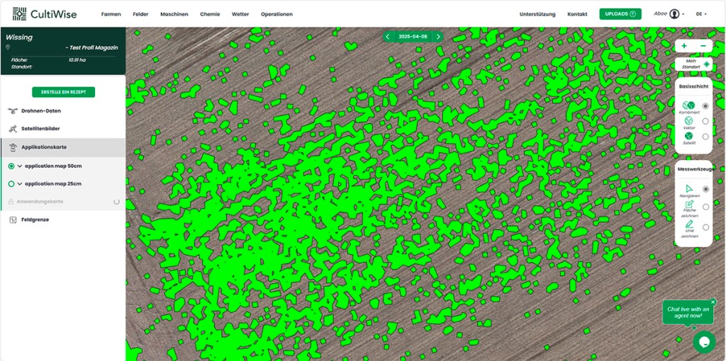
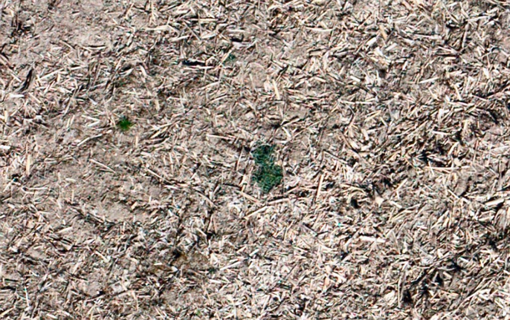
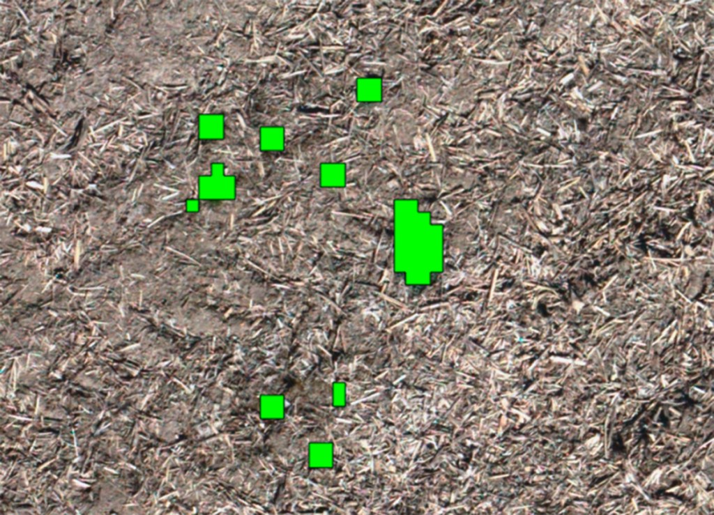
The purpose of flying over the unplanted field was to determine the level of weed infestation or spot thistle patches. The farmer wanted to drill maize and apply a total herbicide before seedbed preparation. Using the CultiWise map enables spot spraying, i.e. applying the chemical only in weed-infested spots. In this specific case, the herbicide application by map could save around 87% of the product at a 50cm nozzle spacing and around 97% of the product at 25cm nozzle spacing.
Planning the treatment maps
To generate the respective application map for the planned measures, a ‘recipe’ has to be created in CultiWise. Unfortunately, the translation from Czech into German still is not completely spot on. Titan Machinery has promised to address that soon.
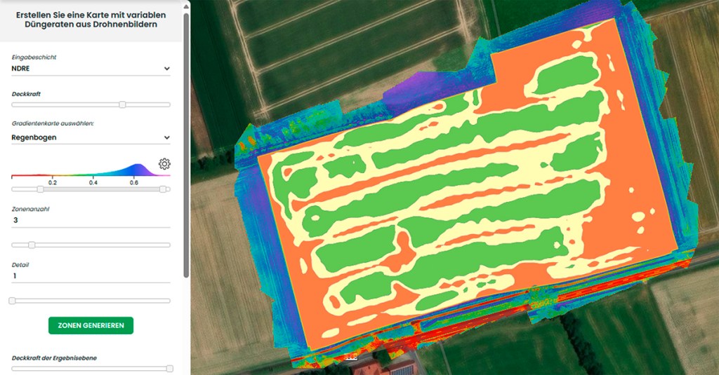
For growth regulator application, the user selects ‘Regulator’ and is advised to use the NDRE map. Using sliders, opacity, colour gradations and colour contrasts in the map can be selected. The number of zones between 2 and 10 is also set. For growth regulator application, three zones should be enough.
If you want to create a spot-spraying map for a herbicide treatment, select either a total herbicide or a selective herbicide. In the first case, it is enough for the AI to distinguish between green and brown and thus find the green plants in the drone photos.
In the settings menu for spot spraying, you should select the orthophoto and the NDVI field as background for distinguishing between green vegetation and brown soil, and thus for a ‘spray or not spray’ decision. A slider can be used to set the threshold more towards one side or the other.
Then enter the ‘section size’. This refers to the nozzle spacing, for example 25 or 50cm, or the boom section. You can also use a buffer setting to specify, in 10cm steps, an area around the spots that the sprayer should treat as well.
Finally, you select the application rate and the control terminal used for spraying. Depending on the terminal, CultiWise generates the correct format for exporting the job file, for example for the Case IH AFS 700 Pro, the Claas Cebis, the Fendt One, the John Deere Terminal Gen. 4 or 5, and also for various sprayer terminals such as the Amatron 4 from Amazone or the eosT10 display from Horsch. In principle, CultiWise can output application maps in Isoxml and Shape formats.
Once you have submitted a new recipe, it takes up to 15 minutes before it appears on the screen. As soon as the new application map is available, you receive an e-mail to let you know.
Further points worth mentioning
According to the manufacturer, a ground resolution of 2cm is enough for the AI image analysis of green on brown. When mapping, the CultiWise Mini then manages around 30 ha/hr, while the CultiWise Scout delivers 150ha/hr.
Anyone who signs up for a subscription over several hundred hectares gets the CultiWise Mini drone free for the duration of the subscription.
Titan Machinery has been offering field mapping with the CultiWise Scout as a service, at a flat rate of €25 (£21.75) per hectare.
Summary
Spot spraying can sometimes save a significant amount of product. With CultiWise, farmers can create job maps on the basis of drone images. For mapping, the German distribution partner of the Czech provider SkyMaps markets the small CultiWise Mini for €4,200 (£3,654) and the large CultiWise Scout for €34,640 (£30,136). Both are based on DJI models. Thanks to its extra equipment with particularly high-resolution RGB and multispectral cameras, the Scout produces sharper images than the Mini at the same flight height.
Anja Böhrnsen
For more up-to-date farming news click here and subscribe now to profi and save.